From America’s highest peak to its lowest valley, the United States is full of fascinating locations to tempt any explorer. Not only are these destinations prone to vast altitude changes, but also roaring winds, heavy snowfalls, intense rainy seasons, and general remoteness that makes them more challenging to access. Here are 15 extreme destinations worth visiting throughout the United States.
Highest Peak - Denali, Alaska
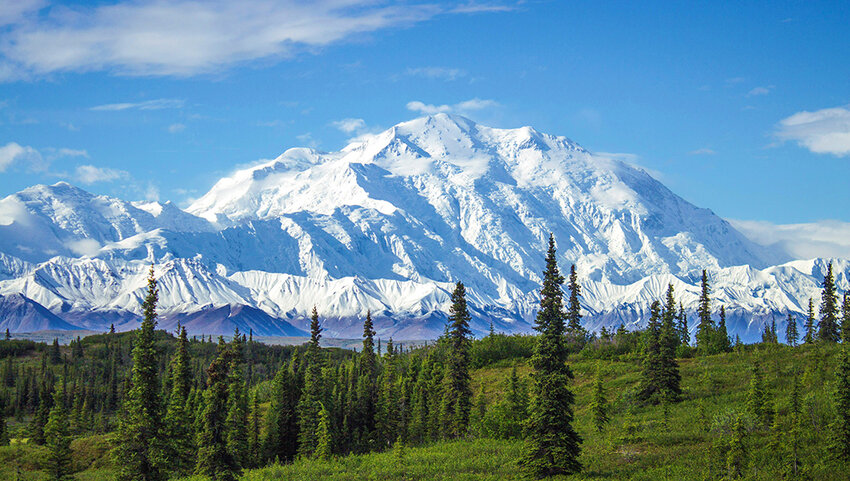
There’s no more extreme location anywhere in the United States than its highest peak. Once known as Mount McKinley, Denali is the tallest mountain anywhere in the country — and all of North America for that matter — reaching heights of 20,310 feet above sea level. This majestic mountain is part of the larger Denali National Park & Preserve, a vast natural expanse that covers six million acres of Alaskan wilderness. The mountain is also known for its isolation and prominence, ranking third worldwide in both categories after Everest and Aconcagua. Denali’s permanently snow-capped peak is also covered in glaciers, many over 30 miles long including the 44-mile-long Kahiltna glacier. The mountain was first summited by three climbers in 1913, and remains a challenging yet rewarding trek for thrill-seekers today.
Lowest Point - Badwater Basin, California
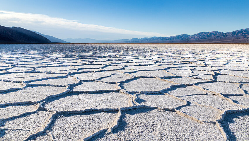
Located a staggering 282 feet below sea level, the salt flats of Badwater Basin denote the lowest point anywhere on the continent. Badwater Basin is located within Death Valley National Park in California and covers a massive area of nearly 200 square miles. The region was formed following the evaporation of Lake Manly. Legend has it that Badwater Basin earned its name thanks to a mule that refused to drink its salty water; this serves as a useful reminder to bring your own water during any visit, as Death Valley is also known for its record-setting high temperatures in the summer.
Highest City - Leadville, Colorado
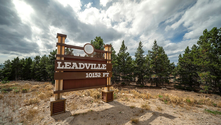
The small town of Alma, Colorado, is considered the highest incorporated municipality in the country, reaching heights of 10,361 feet above sea level. Just a few miles west of Alma, however, is the USA’s highest city, Leadville. With just of 2,600 residents, Leadville sits at an elevation of 10,200 feet. The city’s origins date back to the mid-19th century when the California gold rush brought miners and their families west. At one point, Leadville was the second largest city in Colorado and even considered to become its capital. Though its population has waned over the years, Leadville remains an incredible destination with a picturesque historic district highlighted by incredible Victorian architecture. In addition to its history, Leadville serves as a great city to bike, camp, fish, and partake in every outdoorsy activity imaginable.
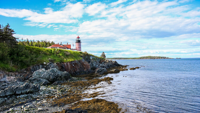
Easternmost Point in the Contiguous U.S. - West Quoddy Head, Maine
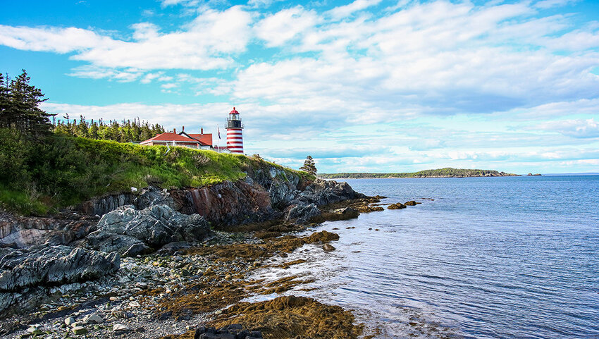
Maine’s Quoddy Head State Park is the easternmost point in the U.S., encompassing 541 acres of scenic parkland at the tip of a peninsula along the Atlantic coast. Here, you'll find the West Quoddy Head Light, a historic lighthouse commissioned by Thomas Jefferson and first built in 1808. The current structure was built a few decades later, in 1858, and allows visitors to gaze out over the Quoddy Channel toward the cliffs of Grand Manan Island in New Brunswick, Canada. Given its proximity to the ocean, this easternmost point also provides opportunities for humpback whale watching.
Southernmost Point in the Lower 48 - Ballast Key, Florida
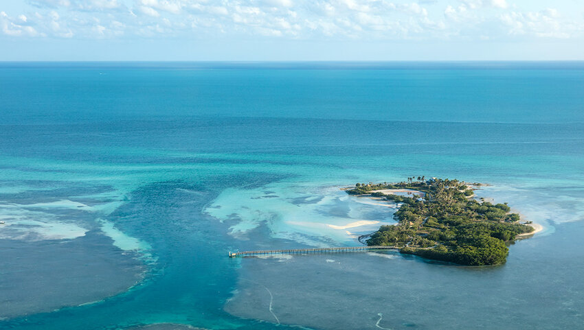
Located all the way down the Atlantic coastline from Maine is Ballast Key, Florida, the southernmost location in the contiguous United States. This tiny island is nestled amid the Florida Keys, specifically within the Key West National Wildlife Refuge. While there are several small tracts of land that sit a bit further south than Ballast Key, those are periodically submerged beneath the ocean waves, unlike Ballast Key which remains above water at all times. A little east of Ballast Key is Key West, the southernmost incorporated village in the Lower 48. While visiting Key West, be sure to take a snapshot with the concrete buoy erected in 1983 that denotes just how far south this extreme destination is.
Wettest Place - Mt. Waialeale, Hawaii
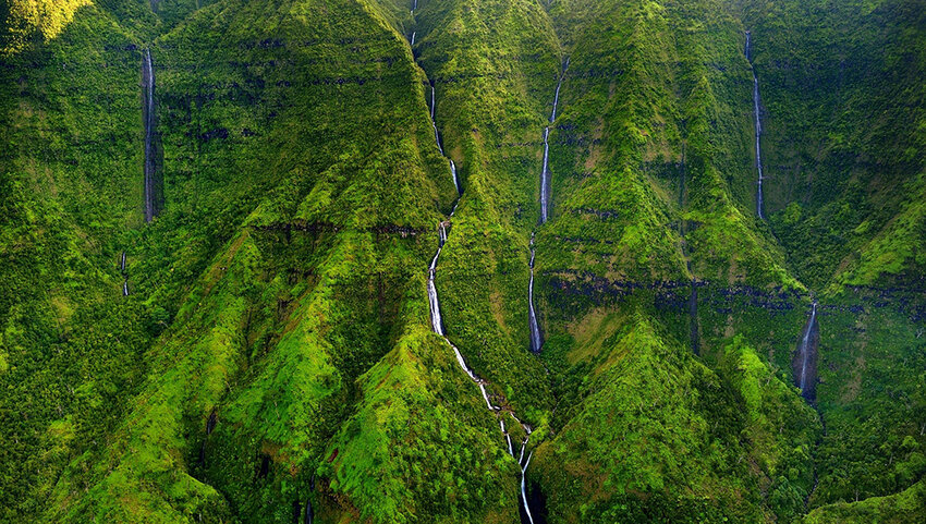
Mount Waialeale is the wettest spot in the United States, and among the wettest spots worldwide. This lush Hawaiian paradise receives approximately 460 inches of annual rainfall, though it set a record with 666 inches of precipitation in the year 1982. Reaching 5,243 feet above sea level, Mount Waialeale is particularly interesting because it receives much more rainfall than its surrounding landscape, which sees only 10 inches of rain a year. No trip to the area is complete without visiting the Weeping Wall, which features cascading waterfalls careening down the mountainside. However, be sure to visit alongside a trained guide, as the slippery terrain can make hiking treacherous.
Snowiest Place - Mount Rainier National Park, Washington
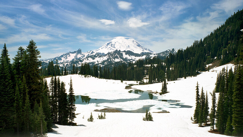
Pack a pair of snowshoes and thermal underwear before visiting Mount Rainier National Park, which is considered the country’s snowiest location. Paradise, an area within the park, is particularly prone to snowfall, averaging 53.6 feet of snow annually. This location even received a record 93.5 feet of snow during the winter between 1971 and 1972. Avalanches are rather common in Mount Rainier National Park, so be sure to travel with caution. That being said, hiking throughout this extreme location is an experience unlike any other assuming you take the proper precautions.
Deepest Lake - Crater Lake, Oregon
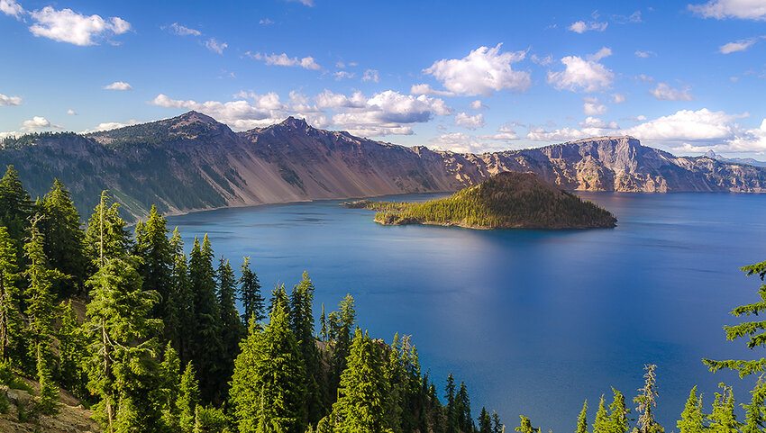
Oregon’s Crater Lake is the deepest lake in America, descending to depths of 1,943 feet — that’s bigger than the Eiffel Tower, Washington Monument, and Statue of Liberty stacked on top of one another! What makes Crater Lake even more special than its extreme depths are its crystalline waters. The lake’s water comes entirely from snow and rain, as there are no other water sources feeding into it, thus giving the water its vibrant blue color. Given the lack of sediment from other potential water sources, Crater Lake is one of the clearest lakes in the world.
Remotest Location in the Lower 48 - Gannett Peak, Wyoming
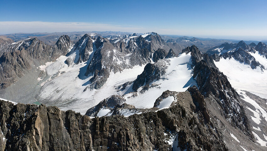
If you’re looking for peace and serenity away from the city, then there’s no more remote location in the contiguous United States than Gannett Peak, Wyoming. This towering crag reaches heights of 13,804 feet, and contains the largest glaciers of the entire Rocky Mountain range. Anyone setting out to reach Gannett Peak has to come well prepared, as there are no campsites along the way. Plus, hikers are looking at a lengthy 20-hour hike, in and out, at minimum. Those adventurous enough to visit Gannett Peak should prepare themselves for 45 miles of hiking and a 9,000-foot vertical climb.
Windiest Place - Mount Washington, New Hampshire
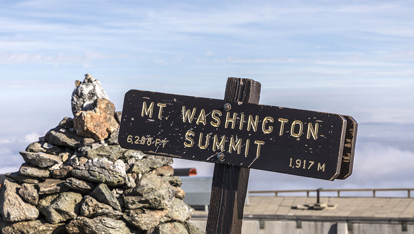
On April 12, 1934, the Mount Washington Observatory in New Hampshire recorded winds reaching speeds of 231 mph, the fastest wind speed ever recorded at the time. Though that record has since been broken by Australian winds of 253 mph in 1996, Mount Washington remains the point with fastest wind recorded on U.S. soil. While you’re unlikely to encounter record winds during your trip, the mountain is still known for its average winds of 35 miles per hour. That, coupled with average temperatures below freezing at 27.1°F, make Mount Washington one of the most extreme points in the country.
Longest Bridge - Lake Pontchartrain Causeway, Louisiana
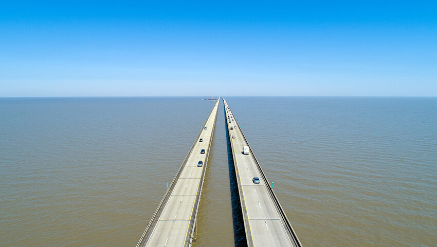
At 24 miles long, Louisiana’s Lake Pontchartrain Causeway is the longest bridge in the country. Composed of two parallel bridges built in 1956, this lengthy roadway once held the Guinness record for world’s longest bridge (though that title has since been contested by a location in China). The bridge connects the Cajun towns of Mandeville and Metairie, the latter of which is a part of the New Orleans metropolitan area. The second longest bridge in the country is also located in Louisiana — the 23-mile-long Manchac Swamp Bridge, which crosses over a body of water that many locals claim is haunted.
Westernmost Point on U.S. Soil - Point Udall, Guam
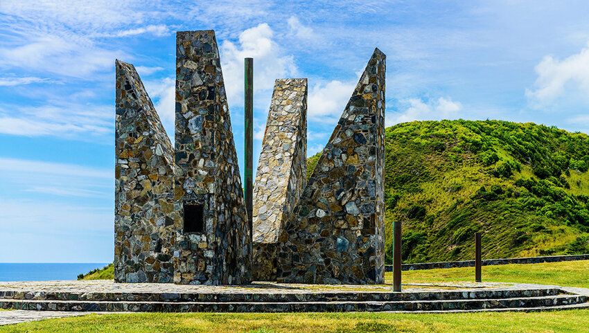
If you venture outside of the contiguous United States, you’ll find that many of the United States’ geographic extremes are located throughout its island territories. The country’s westernmost point is located in Guam, specifically an area known as Point Udall. Rotating around the compass, the southernmost point on U.S. soil is Rose Atoll in the Pacific territory of American Samoa. The country’s easternmost point is Point Udall in Saint Croix, part of the U.S. Virgin Islands, and finally the northernmost point in the United States sits at the tip of Alaska.
Highest Peak East of the Mississippi - Mount Mitchell, North Carolina
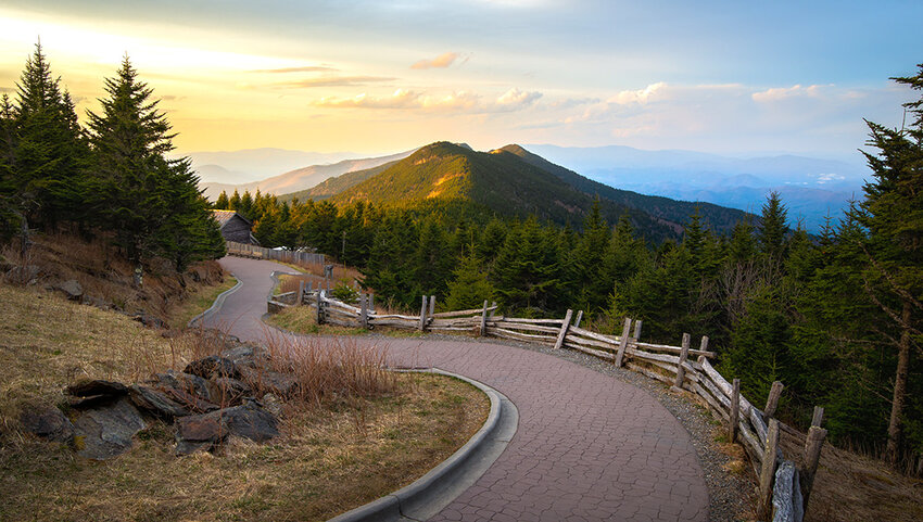
The western United States is known for its prolific mountain ranges, but the East Coast has plenty of impressive geographic formations of its own. Looming 6,684 feet above sea level, North Carolina’s Mount Mitchell is the tallest U.S. peak east of the Mississippi River. It was named after scientist Elisha Mitchell, a professor at the University of North Carolina who first measured the mountain in 1835. The mountain later became part of North Carolina’s first state park in 1915. If you visit Mount Mitchell, be sure to check out the stone observation deck up top, which provides 360-degree views of the beautiful North Carolinian landscape.
America’s Geographic Center - Belle Fourche, South Dakota
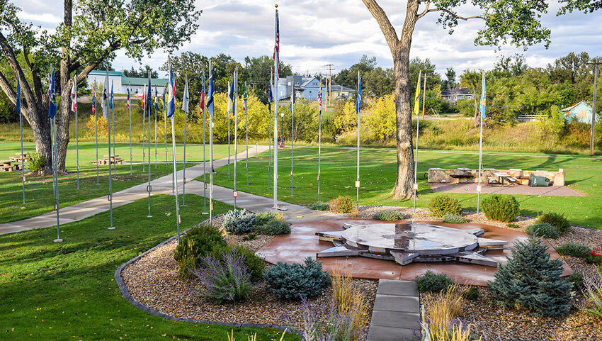
While a spot near Lebanon, Kansas, served as the geographic center of the United States for many years, the addition of Alaska and Hawaii in 1959 shifted that location further north. Today, the geographic center of all 50 states lies just outside of Belle Fourche, South Dakota. The point is located amid the stunning Black Hills in the western part of the state, and a plaque in Belle Fourche denotes that the point is located nearby (about 21 miles outside of Belle Fourche, to be more precise). Today, Belle Fourche features a 54,000-pound monument made from South Dakota granite formed into the shape of a compass that’s etched with a map of the United States.
Shortest River - Roe River, Montana
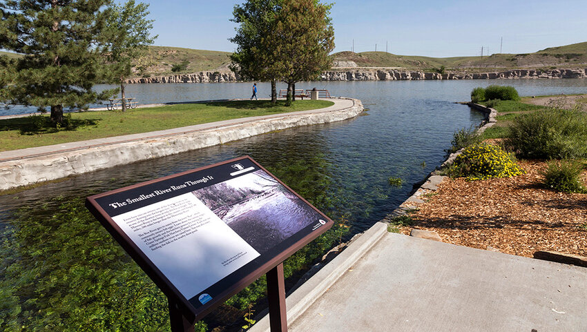
At just 201 feet long, the Roe River is the shortest river in the United States. This flowing waterway was initially unnamed until 1988, when a group of fifth graders from nearby Great Falls, Montana, petitioned the government to name the river. The school children decided on the name Roe River as the state’s fish hatchery was located just nearby. While the Roe River is the smallest American river, it flows parallel to the country's largest river, the Missouri River. In addition to this extremely short river, the town of Great Falls is home to many scenic walking and hiking trails as well as plenty of great fishing locations.