A hike on Oahu will reward you with several things. Panoramic ocean views, trekking through lush tropical forests, and encountering Hawaii’s endemic native flora and fauna, such as the bristled lehua ohia and the fire red apapane, or Hawaiian honeycreeper. And with virtually perfect weather year-round, hiking on Oahu is a great way to experience the island. Here are eight hikes worth the trek, from visiting the island’s most iconic landmark to seeing a 150-foot waterfall and standing atop World War II military bunkers while looking out at the Pacific.
Makapuu Lighthouse Trail
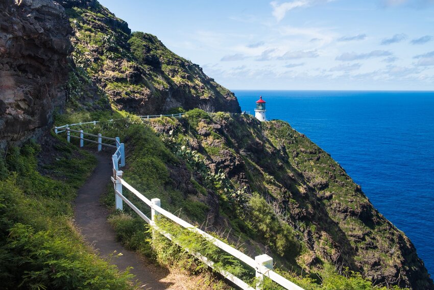
One of the easiest hikes on Oahu is the completely paved, two-mile Makapuu Lighthouse Trail. Yet despite its ease, this path leads to some of the best sites on the island. In the winter, you may even spot a few whales in the distance. At the end of the trail, you get a glimpse of the lighthouse that the hike is named after. But the real highlights are Makapuu Beach Park on the left, Rabbit Island and Kaohikaipu Island State Seabird Sanctuary straight ahead, and the endless Pacific Ocean.
Koko Head Crater Trail
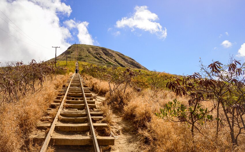
The Koko Head Crater Trail, often simply called Koko Head, is one of the most famous hikes on the island. With its 1,000 steep, rickety steps, this trail is best for those who want to get a solid workout in before taking in the views at the top. The US Army built the trail in 1943 as a railroad track, which still stands today, and its original purpose was to shuttle supplies from the bottom of the mountain to the top. And once you reach the vantage point at the top of the trail, you get a great view of the entire southeastern tip of Oahu – from Waikiki to Hanauma Bay.
Waimano Falls Trail
Hidden away in the Ewa Forest Reserve, this 2.9-mile hike is one of the lesser-known trails on Oahu and has some unexpected twists and turns. The start is flat, semi-paved, and lined with thriving strawberry guava trees before you hit a section nicknamed “Heart Attack Hill,” which, needless to say, is anything but easy. This steep, downward slope tests all of your muscles as well as your mind as you navigate the smartest path to take. While Heart Attack Hill is one path, it’s very wide, so you have to decide how exactly to get down. You can stick to the edge of the path for less wear on the trail, wind from tree to tree for balance, use the tree roots as natural “steps,” or find another strategy that works best for you.
Once you make it to the bottom, Waimano Falls isn’t too far behind. This 25-foot cascade is already stunning enough on its own, but there are also a couple of swimming holes, a cliff jumping spot, and even a rope swing for you to enjoy before heading back. Do note that you’ll have to make your way back up Heart Attack Hill on your return journey.
Diamond Head State Monument

One of the defining landmarks of Oahu, Diamond Head is a volcanic tuff formed about 300,000 years ago. It got its name from 19th-century British sailors who thought the shining calcite crystals found on the crater were diamonds. Native Hawaiians called the extinct volcano Leahi. Meaning brow of the tuna in Hawaiian, they thought the crater’s slope looked like an ahi, or tuna head. Today, it’s a state monument and an iconic Oahu hike. The .8 mile trail includes switchbacks and 99 steps, but is still an easy-to-moderate hike that ends with panoramic vistas of the island, from the nearby Koko Head crater, downtown Honolulu and Waikiki to Oahu’s west side. Note: There’s an entry fee of $5 per vehicle or $1 per walk-in visitor.
Manoa Falls
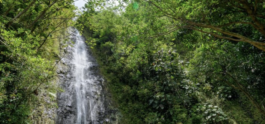
While the other Hawaii islands boast the more impressive waterfalls, many towering at hundreds of feet, Manoa Falls is still worth the visit. Tucked in the lush Manoa Valley, just outside of Honolulu, this trail is well maintained, albeit often muddy, thanks to the frequent rain. The .8-mile-hike ends with a public viewing area of the 150-foot waterfall and surrounding pool. Be sure to bring mosquito repellent for this hike.
Lanikai Pillbox Trail
Officially known as the Kaiwa Ridge, this nearly one-mile out and back hike is better known by its colloquial name, the Lanikai Pillbox Trail. That’s because of the two military observation stations built during World War II. The trail, located in the tranquil neighborhood of Lanikai on Oahu’s Windward side, is a popular hike. In fact, the hike was closed for roughly two months this summer so $250,000 in repairs could be made to the bunkers from heavy use. The rocky, dusty trail is unshaded and has a sloping incline. What it lacks in cover, it makes up for in sweeping views of Lanikai, Kailua, the Koolau Mountains and the Mokulua Iki and Mokulua Nui, two offshore islets. Meaning “two islands,” the pair are known as the Mokuluas.
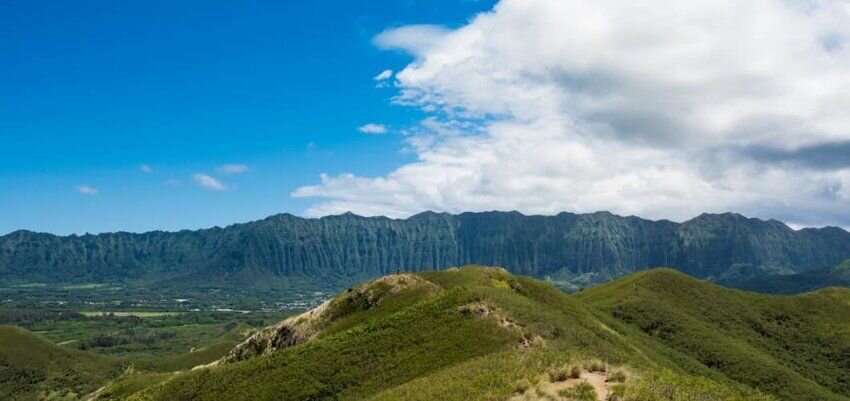
Kuliououou Ridge Trail
Want to earn that stunning view at the end of your hike? Then head to Aina Haina, a neighborhood in east Oahu, where the trailhead for the quad-burning Kuliouou Ridge Trail is located. The 2.5-mile, one-way trail ends at the summit of the Koolau Mountain range. With a 2,000-foot elevation gain and dozens of steps, this hike is recommended for intermediate to advanced hikers. The trail winds through Norfolk pine, ironwood, guava, formosa koa and Christmas berry. Roughly two-thirds into the hike, relief comes in the form of two covered picnic tables. From there, the trail continues to incline and there are stairs at its steepest parts. There are great views of windward Oahu and Waimanalo along the way, and at the top, a near 360-degree view of the island.
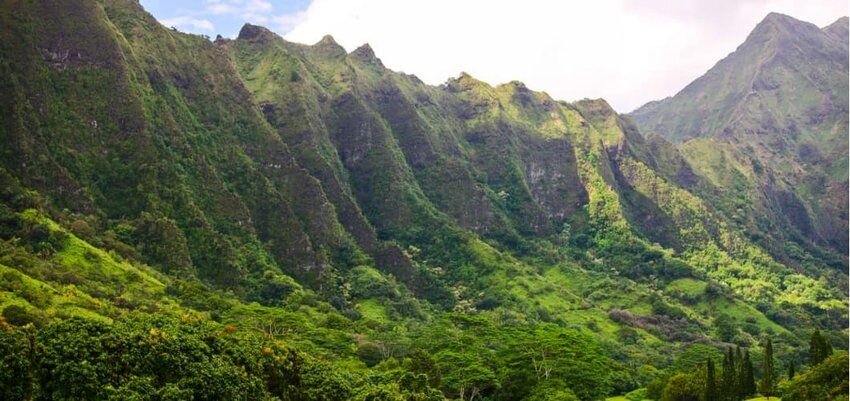
Aiea Loop Trail
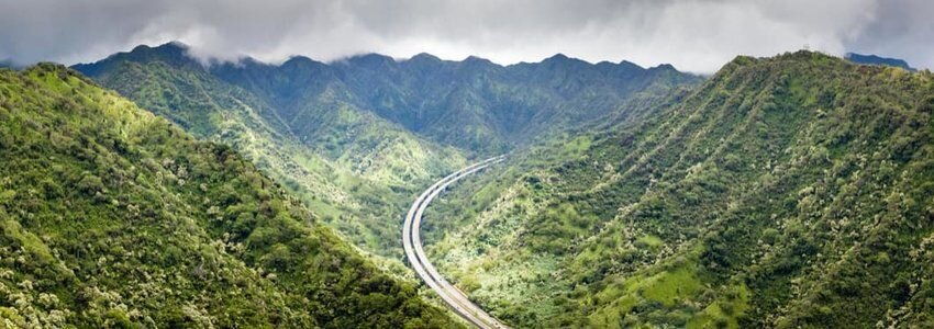
This 4.8-mile loop hike is an oasis just 20 minutes from the hustle and bustle of Honolulu. Hugging the western slopes of Halawa Valley located in central Oahu, the trail begins and ends in the Keaiwa Heiau State Recreation Area, a 384-acre park and campground. There’s a 900-foot elevation gain along the way, a small stream crossing and rooted areas, but much of the trail is shaded with lemon eucalyptus trees — giving the air a slight fragrance — Norfolk pines and higher up, native ohia and koa trees. The trees give way to views of south Oahu, from Pearl Harbor to Honolulu and Diamond Head. From here you can also see the island’s H-3 highway, considered the nation’s most beautiful freeways, and its most expensive one.
About the authors:
Sarah Etinas is a Hawaii local and full-time travel writer who has written for Time Out, Honolulu Magazine, and The Culture Trip amongst others. When she's not writing, Sarah practices what she preaches by traveling to new destinations, hiking to beautiful waterfalls, and exploring her home.
Tiffany Hill is a writer and editor based in Honolulu who specializes in travel, culture, and business writing. Her work is regularly published in regional, national and online publications. When she’s not on assignment, you can find her playing roller derby.